
Sometime prior to 1883, Land Lot 138 was owned by James Willis Vaughn (1850 – 1925). He owned the entire 202 ½ acres. According to the 1880 Census, the 26-year-old North Carolina native, James W. Vaughn, was living at 254 North Calhoun Street in the 5th Ward of Atlanta. His occupation was the Bailiff of the City Court. He was married to 20-year-old Annie J. Vaughn. On February 19, 1883, J.W. Vaughn gave seventy-five acres to his wife, Annie J. (nee Crusselle) Vaughn (1859-1926). Annie Vaughn’s father was Thomas George Washington Crusselle (1822-1890). Mr. Crusselle was a stone mason by trade and resident of Atlanta when it was simply the eastern terminal of the Western & Atlantic Railroad. He reported immigrated from North Carolina in 1838 to help build the first bridge across the Chattahoochee River for the W&A Railroad. According to the 1910 Census, James Vaughn was living in Atlanta on Merritt’s Avenue and listed his occupation as Sheriff, Supreme Court. Lewis Jeremy Blanton (1871-1937), a physician, was living with him as his son-in-law and having married his daughter, Julia E., in about 1902. A city directory from the same time listed the address as 25 Merritt’s Avenue.
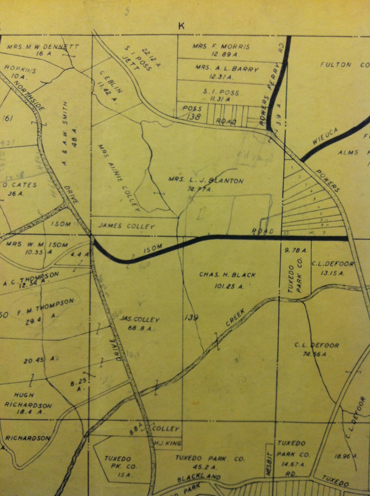
The property does not change ownership again until November 15, 1935. Mrs. Annie J. Vaughn’s will was probated in July 1928. Julia Ella (nee Vaughn) Blanton was deeded about 59.33 acres of the 75 acres. The 56 acres was described as bounded by Powers Ferry Road to the east, Hillside Drive (then Isom Road) to the south, Jett Road to the north, and the centerline of the creek that bisects Jett (with three foot waterfall described in the deed) and Hillside Drive to the west. On March 31, 1936, Mrs. Blanton had deeded this land to her son, Lewis Vaughn Blanton. She had previously given the land on November 7, 1934 but another deed is recorded to “correct the description of land intended to be conveyed.” Thus, the land passed through the estate of J. W. Vaughn to his wife, then his daughter, and then grandson (Lewis Vaughn Blanton). The Vaughn / Blanton family had held portions of the property for nearly sixty years.
The photo is of Julia Ella Blanton, whom Blanton Road is most likely named after.
According to the 1930 Census, Lewis V. Blanton (1904-1970) was 25 year old living with his physician father, Lewis J. Blanton, and mother, Julia E (nee Vaughn) Blanton (1880-1940). Lewis V. Blanton was occupied as a civil engineer for the city. The family lived at 511 North Avenue, Atlanta, Georgia. The family did not live on the country (i.e., Isom Road) property. Lewis V. Blanton’s father, Lewis J. Blanton, passed away on April 6, 1937.
On December 22, 1937, Lewis Vaughn Blanton conveyed a portion of his lands to Mrs. Hazel L. Meredith. The tract conveyed contained approximately eleven acres. This is the first deed to note the road as “Hillside Drive (formerly Isom Road).” The property had about 500 feet of frontage on Hillside Drive. It ran from where the current east property line of 399 Hillside currently starts westerly to the centerline of the creek on Hillside Drive. The property line then followed the creek north to approximately a point near where Blanton Road and Dykes intersect. However, Dykes Drive did not exist and was part of the property. Blanton Road did not exist and is only described as the “proposed 50 foot road” to the north end of the property. The deed restricted the Merediths for “residential purposes only,” putting no building within 150 feet of Hillside Drive or the proposed Blanton Road, and the residence will cost no less than $8,000 to build.
Of note, Lewis Blanton reserved the right to “inundate such portion of” the tract “as will be necessary to form a lake . . . to an elevation of eight hundred fifty (850) feet above mean sea level.” The deed also allowed the Meredith to put a boat house on the shore of the proposed lake.
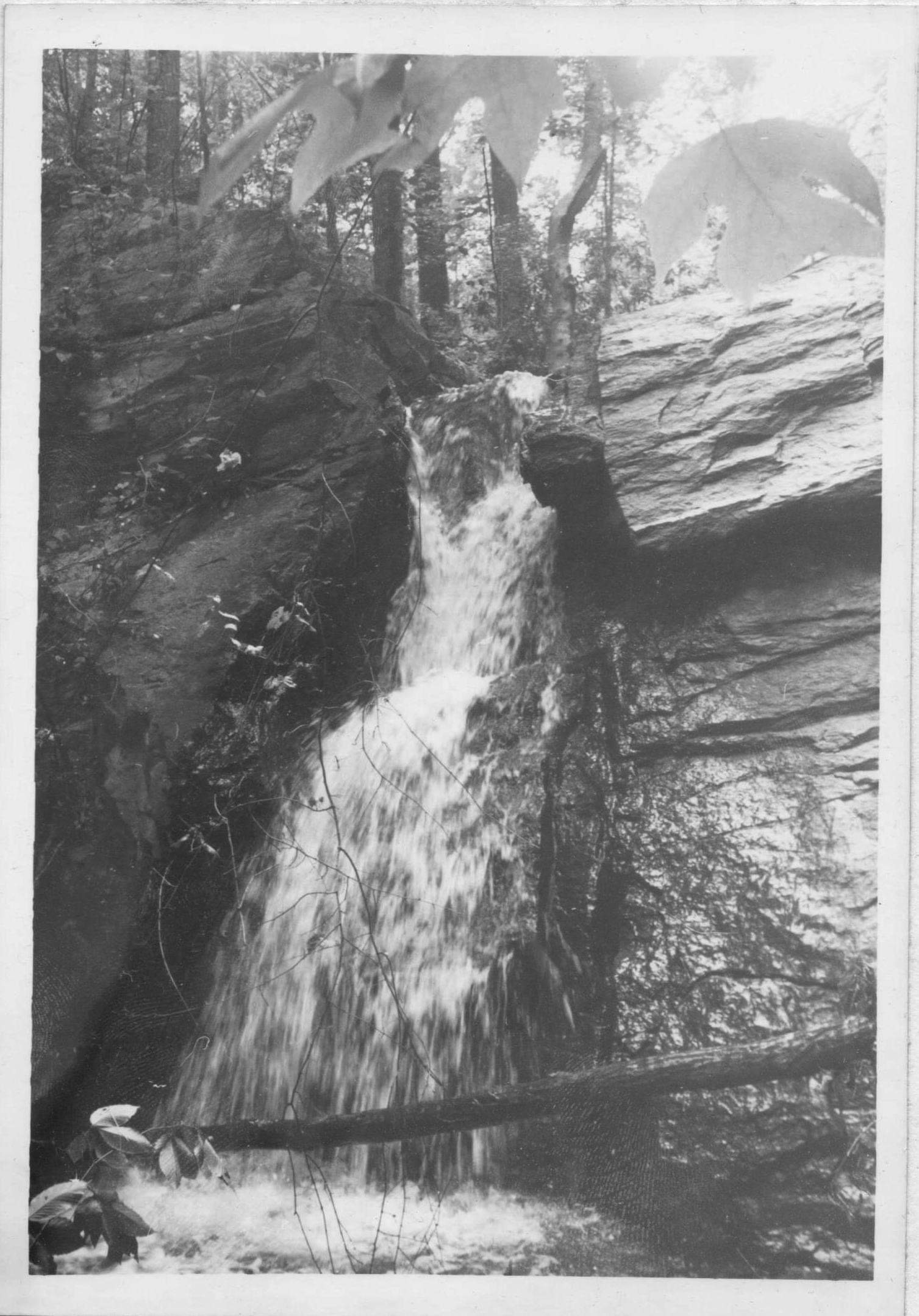
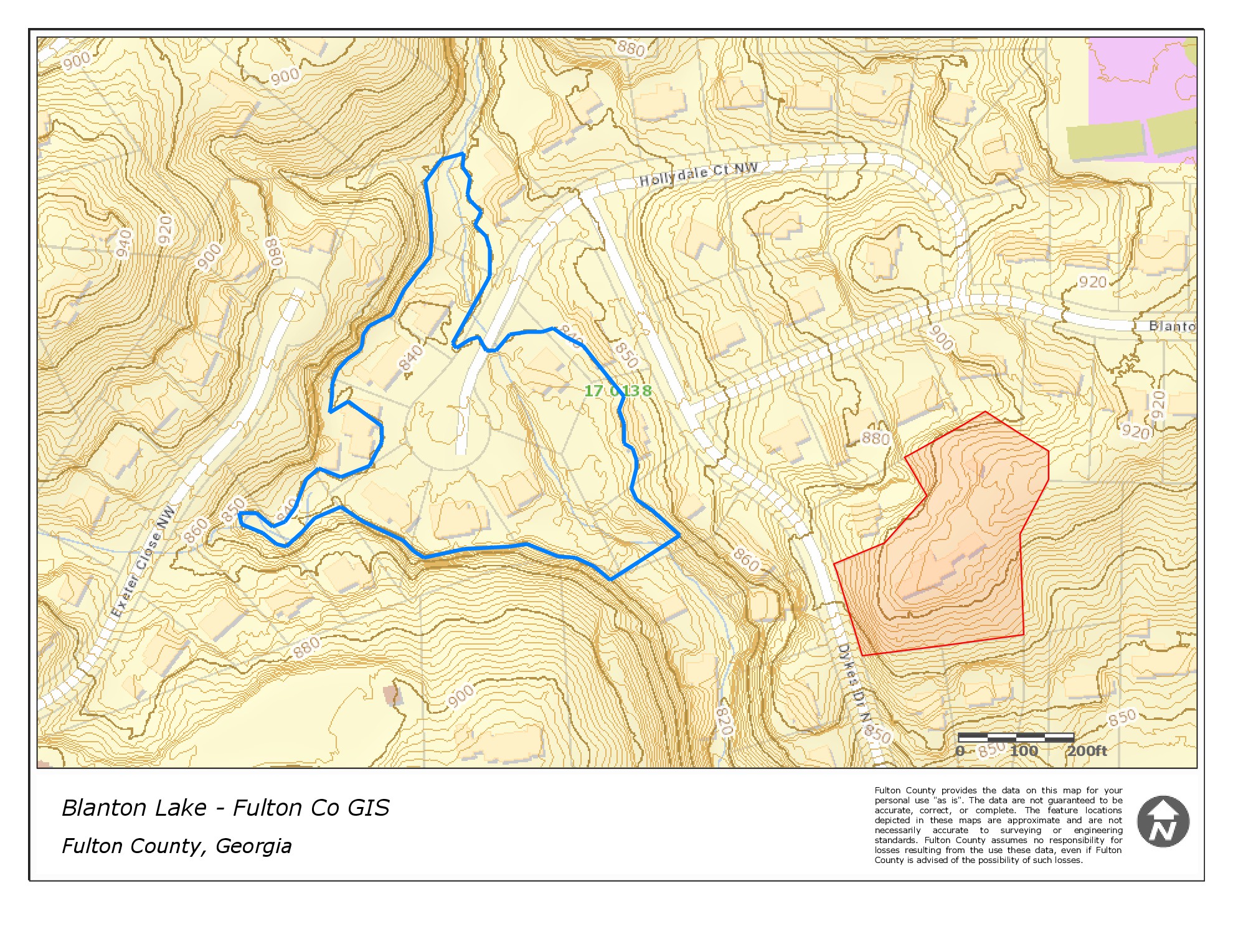 Lake? There is no lake nearby currently. Lewis Blanton never inundated his property. The dam was never built. However, he clear cut the land for timber and quarried rock. This left a relatively flat deforested area for the proposed lake. The current Hollydale Court cul-de-sac was all at the bottom of his proposed lake. An aerial photo from 1938 of the area shows a clear cut area in the exact shape of the Hollydale Court area. Topographic maps reveal that all this land is below the 850 mean sea level and the creek bisects this land. Also, the residents of Meredith House from 1954 to 1962 reported remnants of a large “saw mill”, piles of saw dust, a mill road, and a waterfall between their property and Jett Road. This would fit with Blanton cutting the forest for lumber and quarrying stone. Hollydale Court has no visible old-growth trees. This was the lake that never was.
The waterfall was either a natural topographic feature or the remnants of the quarrying operation. A photograph by Ted Gordon captured the falls in 1972.